
|
|
|
|
|
|
|
Flower Sniff'n
|
The rules for you are simple. There will be a notebook or easel in the lobby of the hotel. We request that you sign out and give some information to let us know which direction you're heading each morning and then sign back in on your return. There's no telling what will happen on the road and, again, for safety reasons it would be beneficial to know which direction you're heading just in case we don't hear from you.
If you want a good hand at the end of the week, then we have to set a few guidelines even for the sniffers in the group. So here are the rules for all sniffers who are participating in the pot:
So that's the official rules for sniffin at the PRFH. However, there are a few things worth mentioning.
If you're planning on leading a group, please be sure you set the ground rules for the ride - especially if you've never shared the road with the folks you're riding with. Discuss things like range, how often you plan to stop, if you'll keep a tight group, hand signals, etc. Basically, get familiar with each other and try to keep the surprises to a minimum. Tight groups are strongly discouraged. There is a lot to see and take in while in Arkansas and the roads are often twisty. Small single file groups are better that large, tight groups, even if they are in staggered formation. Spread out, be safe and enjoy the ride.
In addition to the sign out/in notebook in the lobby, there will be another notebook or easel people can use to indicate where they're going and what time they plan to leave. This will help folks hook up in the morning and ride together, if they choose to do so. Since folks will be staying at the hotel as well as the campground, this should help us better communicate with each other. For those participating in the PRFH Pot, please note, this information is not the same as your intended route required to sign out properly each morning.
Since all of this information will be at the hotel, it makes sense to begin and end all rides at the hotel.
Have fun, take pics, write in your journal and share your experiences with us all. Arkansas is a precious area to ride. The best advice I'm able to give is take advantage of the time you'll be there. I hope you all decide to sniff as much as you can stand.
If you're looking for excuses to ride, then there are plenty to choose from. The following sections provide information on restaurants, must-do roads and interesting places to see. Combined with the suggested routes, you will find plenty of destinations and many different ways to get to/from each one.
Obviously, the list of excuses has no end and to that end, if you have any suggestions, don't hesitate to chime in.
| Russellville | |
| What-A-Burger 1410 N Arkansas Ave 501 968 1410 Good Burgers and Shakes |
|
| Ole South Restaurant 1330 E Main St 501 968 3789 Don’t miss it for breakfast |
|
| Stobey’s Depot and Dining Car Restaurant 405 W Parkway Dr 501 968 3816 |
|
| Hot Springs | |
| Hot Springs Brau Haus 801 Central Ave 501 624-7866 |
|
| McClard’s BBQ 505 Albert Pike Road 501 624 9586 World Famous BBQ, Slick Willie hangout |
|
| Purity BBQ 1000 Malvern 501 623 4006 |
|
| Eureka Springs | |
| Myrtie Mae’s – at BW Inn of the Ozarks Highway 62 W 479 253 9768 Hungry? Get the Double Burger |
|
| Autum Breeze 190 Huntsville Road 501 253 7734 Chocolate Soufflé |
|
| Benton (Little Rock Area) | |
| Brown’s Country Store and Restaurant 18718 Interstate 30 501 778 5033 Breakfast and Dinner |
|
| Fayetteville/Springdale | |
| Herman’s Ribhouse 2901 N College Ave Fayetteville, AR 479 442 8671 |
|
| Mountain Home | |
| Couch’s BBQ 1508 Highway 62 E 870 425 5525 Great BBQ |
|
| Lakeview | |
| Gastons Restaurant (870) 431-5203 |
|
| Jasper | |
| The Cliff House Located six miles south of Jasper on AR-7. Open 8-3 daily. 870 446 2292 |
|
| Calico Rock | |
| Don Quixotes Calico Kitchen 103 Main St 870 297 8899 |
|
| Altus | |
| Wiederkehr Wine Cellars and Weinkeller Restaurant 3324 Swiss Family Drive 800 622 WINE |
|
| Yellville | |
| Front Porch Restaurant 437 Highway 62 E 870 449 5500 |
|
| Harrison | |
| Ol’ Rockhouse 416 Pine S 870 741 8047 |
|
| Mena | |
| Skyline Cafe 618 Mena St (501) 394-5152 |
|
| Ozark, MO | |
| Lambert’s Cafe 1800 W State Highway J 417 485 5830 |
|
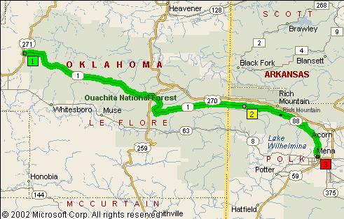
Talimena Scenic Byway: The Talimena Scenic Byway runs from just north of Talihina, OK east to Mena, AR along the crest of the Ouachita Mountains - the tallest mountain range between the Rockies and Appalachians. On a map the Talimena is comprised of highways OK-1 and AR-8. This is a magnificent stretch of road with plenty of scenic overlooks, hiking trails and various other historical sites. Be sure and stop in at the Wilhemena Lodge for some cobbler or stop by the Skyline Cafe in downtown Mena for some good country cooking. But get to the Skyline before 2pm because they like to go home early.
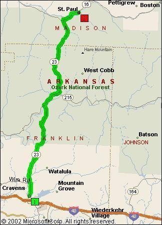
Pig Trail Scenic Byway: The Pig Trail got it's name from the locals of the area who thought the road reminded them of the trails created by pigs as they wander the woods. The Pig Trail officially runs for 30 miles along AR-23 between Ozark, AR and St. Paul, AR through the Boston Mountains. There are seasonal waterfalls, isolated farms and ranches and gives off a real sense of rural America. While the Pig Trail itself is only 30 miles long, the entire length of AR-23 is worth riding from beginning to end.
Be careful when running the Pig Trail as large trucks frequent AR-23 and some of the corners are extremely tight requiring trucks to use the entire road.
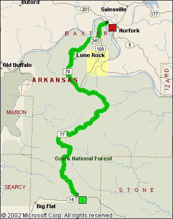
Push Mountain Road: Push Mountain road is known as Arkansas' Dragon. I'm not too sure about that, but I am sure that if you don't run this stretch of road, you will live to regret it and hate yourself when you finally run it sometime in the future. The road itself runs along AR-314 between Big Flat, AR and Norfolk, AR for 25 spectacular miles of twists, climbs and decents. Don't miss it. Note that in some mapping software I've seen the road designated as AR-77 or AR-79, but the signage along the highway indicates AR-314.
Arkansas Highway 9: There's a stretch of AR-9 that is mezmerizing both in terms of road traveled and scenery. It runs the 25 miles between Melbourne, AR and Mountain View, AR. After running Push Mountain Road, drop down and over to Melbourne and run this stretch of AR-9.

Arkansas Highway 16: AR-16 from St. Paul, AR all the way over to Clinton, AR is one of the best roads through the Ozarks. Long sweepers, sharp curves and steep grades are combined with good roads that stretch for 130 miles through the Ozarks. I hate to sound like a recording, but this is a must-do stretch of road while you're in the region. Don't be foolish and not make this run.

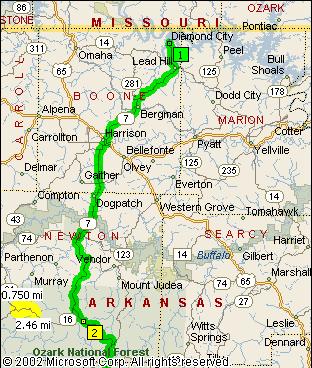
Arkansas Highway 7: Arkansas state highway 7 is the spinal column of the Ozarks and the likely route of most tourist traffic through the Hot Springs area and points northward all the way to its end just a few miles from the Missouri border in Diamond City, AR. This road is best traveled during the week with the best sections experienced from just north of Hot Springs in Jessieville all the way north for 160 miles to Diamond City.
There is no shortage of excellent roads to get to any of these places. I've been to only a few, but you may find some of them interesting enough to visit.
Pea Ridge National Military Park
Located just east of Pea Ridge, AR on US-62. For more information go to the Pea Ridge National Military Park web site.
Withrow Springs State Park
33424 Spur 23
Huntsville, AR 72740
Email: withrowsprings@arkansas.com
Phone: (479) 559-2593
For more information go to the Arkansas State Parks web site.
Buffalo National River
Taken from the NPS website: Headquarters is located in Harrison, Arkansas, providing administrative services to the national river. The Tyler Bend Visitor Center, the main visitor center for the park, is located eleven miles north of Marshall, Arkansas. The park has two other visitor contact stations; the Pruitt Ranger Station, located five miles north of Jasper, Arkansas on Highway 7, and Buffalo Point Ranger Station, located 17 miles south of Yellville, Arkansas, on Highway 14.
For more information go to the National Park Services web site.
Old Hardy Town
Hardy, AR.
For more information go to the Old Hardy Town web site.
Blanchard Springs Caverns
Located 15 miles northwest of Mountain View off AR-14.
Phone: 1-888-757-2246.
For more information go to the Blanchard Springs Caverns web site.
Jacksonport State Park
205 Avenue Street
Newport, AR 72112
Email: jacksonport@arkansas.com
Phone: (870) 523-2143
For more information go to the Arkansas State Parks web site.
Crowley's Ridge State Park
2092 Highway 168 North
Paragould, AR 72450
Email: crowleysridge@arkansas.com
Phone: (870) 573-6751
For more information go to the Arkansas State Parks web site.
Hampson Museum and State Park
P.O. Box 156
Wilson, AR 72395
Email: hampsonmuseum@arkansas.com
Phone: (870) 655-8622
For more information go to the Arkansas State Parks web site.
Fort Smith Museum of History and National Historic Site
For more information go to the Fort Smith web site.
Holla Bend National Wildlife Refuge
Route 1, Box 59
Dardanelle, Arkansas 72834
Phone: (501) 229-4300
For more information go to the Holla Bend web site.
Mingo National Wildlife Refuge
Mingo National Wildlife Refuge is located in southeast Missouri near Puxico.
For more information go to the Mingo Refuge web site.
Big Oak Tree State Park
East Prarie, MO.
For more information go to the Big Oak web site.
Laura Ingalls Wilder Home
3068 Highway A
Mansfield, MO 65704
(417) 924-3626 or 1-877-924-7126
For more information go to the Laura Ingalls Wilder Home web site.
Ralph Foster Museum
College of the Ozarks
Point Lookout, MO
417-334-6411
For more information go to the Ralph Foster Museum web site.
There are five main routes that cover the vast majority of known good roads. I call these power-sniffin routes because each one is 400+ miles long without any particular destination in mind. They serve a few purposes. Primarily as a great for those power-sniffin folks to see a great deal of Arkansas and southern Missouri, but also as a means for the flower-sniffin folks to become familiar with the best roads to wherever they're headed. If you have a favorite place (road, scenic overlook, restaurant...) and you would like to share it with your fellow sniffers, please let us know. I'll be glad to add it to the list. The only things to be aware of are:
So don't be bashful about sharing your favorite places in Arkansas and southern Missouri with us all. If you don't have a mapping program, just post the roads and I'll map it for you. No problem.
These routes cover some of my favorite roads in northern Arkansas and a few in southern Missouri as well as some roads I've never been on. I plan on riding each of these routes during the PRFH and hope that some of you will join me.
Each of these routes is at least 400 miles long with stops at least every 75-90 miles, but there are bail out points along the way if anyone doesn't feel like riding the entire route. Each route also has a theme.
Click on the maps to download Microsoft Streets &
Trips 2003 file.
If you have trouble, Right Click on the map and select "Save Target
As".
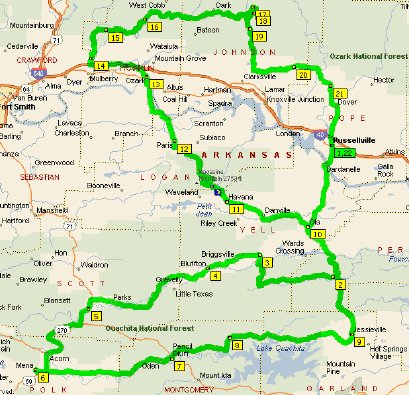
Talimena Scenic Byway - This route will take us southeast to Mena, the Skyline Cafe and the Talimena Scenic Byway. If you've never ridden the Talimena, this is a good route. We'll be riding it twice. :)
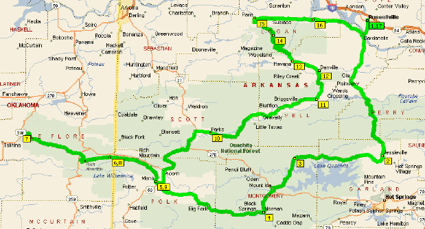
AR-7 south to Jessieville
AR-298 west to Story
AR-27 south to Norman
AR-8 west to Mena
AR-88/OK-1 west to US-271 (This is the Talimena)
OK-1/AR-88 east to Mena
US-71 north to Boles
AR-28 east to Rover
AR-27 north to Danville
AR-10 west to Havana
AR-390 north to Paris
AR-22 east to Dardanelle
AR-7 north to Russellville
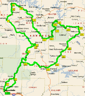
The Pig Trail - This route will take us north into Missouri and west over to the beginning of highway 23. We'll ride 23 from the Missouri/Arkansas border to I-40 where we'll pass through the famous and magical Pig Trail.
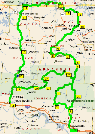
AR-7 north to AR-164
AR-164 west to AR-123
AR-123 north to Vendor
AR-74 west to Ponca
AR-43 north to Harrison
AR-7 north to Bergman
AR-281 north to AR-14
AR-14 west to Omaha
US-65 north to MO-86
MO-86 west to MO-P (Turns into AR-23 when crossing the border)
MO-P/AR-23 south to I-40
AR-23 north to AR-215
AR-215 east to AR-21
AR-21 north to AR-16
AR-16 east to AR-7
AR-7 south to Russellville
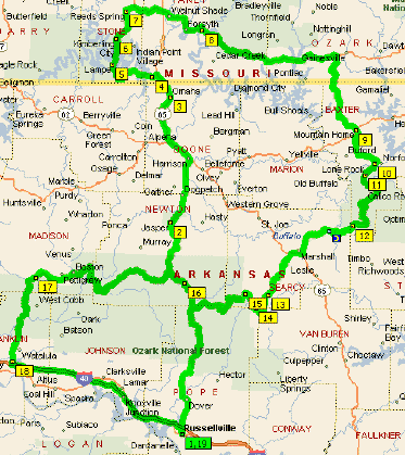
Push Mountain Road - This route takes us north to the beginning of highway 14 and southeast to Push Mountain Road. PMR has been termed as Arkansas' Tail of the Dragon. I try to find an excuse to run this area everytime I go to Arkansas. PMR alone is worth a trip to Arkansas. We'll also ride a stretch of highway 9 that is simply amazing and a must-do stretch of road for anyone on two-wheels.
AR-7 north to Dover
AR-27 north to Marshall
US-65 north to Harrison
AR-7 north to AR-281
AR-281 north to AR-14
AR-14 south to Big Flat
AR-341 north to AR-5
AR-5 south to Calico Rock
AR-223 north to AR-56
AR-56 east to Brockwell
AR-9 south to Clinton
AR-16 west to AR-27
AR-27 south to Hector
AR-105 south to AR-124
AR-124 south to Russellville
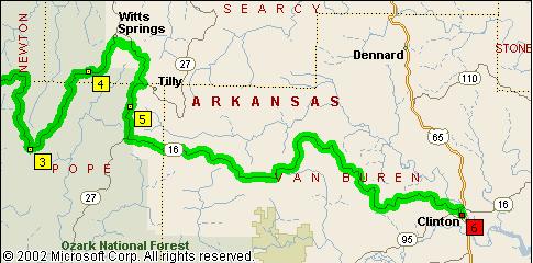
Little Misery - This route will take us north into Missouri for a little ride through the Mark Twain National Forest and east along 160 then south to Mountain Home, Arkansas where we'll ride PMR and head for Russellville. This also happens to be the longest route too. So it's called 'Little Misery' for a couple of reasons. I'm thinking about running this one on Wednesday. :)
AR-7 north to Harrison
US-65 north to MO-86
MO-86 west to MO-13
MO-13 north to Reeds Spring
MO-248 east to MO-160
MO-160 east to MO-5
MO-5/AR-5 south to Norfolk
AR-341 south to AR-14
AR-14 north to Harriet
AR-27 south to Tilly
AR-16 west to St. Paul
AR-23 south to I-40
I-40 east to Russellville
Country Roads Tour - This route will take us along some nice meandering country roads southeast and northeast of Russellville. There will be some good opportunities for taking some great pics of old barns, buildings and such. Just a nice, liesurely stroll through the country.
AR-7 south to AR-314
AR-314 west to AR-27
AR-27 north to Rover
AR-28 west to US-71
US-71 south to Mena
AR-88 east to AR-27
AR-27 north to Story
AR-298 east to Jessieville
AR-7 north to Ola
AR-10 west to Havana
AR-309 north to Ozark
I-40 west to AR-215
AR-215 north/east to AR-21
AR-21 south to AR-292
AR-292 east to Hagarville
AR-164 east to AR-7
AR-7 south to Russellville
For the flower-sniffers in the group I would recommend finding an excuse to ride from the information provided above and then through a combination of the power-sniffin routes and your own maps you will get an idea of how you want to get there. If you stay on Arkansas state roads, you're almost assured the road will be a good one. I was going to develop routes to various places, but the consumate flower-sniffer doesn't want a detailed route plan, but a general idea of the direction to head. The nose will lead you along from there.