
The 2005 MTF Poker Run From Hell
The Sniffin' Rides
Ride The 3's
|
The 2005 MTF Poker Run From Hell |
The Sniffin' Rides |
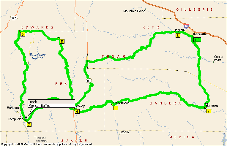
This ride is what the Hill Country is all about. On any given spring or fall day, you can see more bikes here than you can imagine. While that does create some congestion and attracts some rather rigid speed enforcement, it speaks volumes for what is maybe the best 3 or 4 roads in one area anywhere. This ride does ride longer than you would think. Your average speed will not be what your probably used to. Go back and read all the caveats on the Sniffing page again before riding this ride, because they all apply here. On the other hand, you get great roads, some great views, and some real variety. If you want to add a stop, the motorcycle museum just north of Vanderpool is worth a stop, but it is also worth a call to see if they are open as they keep erratic hours. The lunch buffet at the Mexican restaurant in Camp Wood is excellent.
The return trip is up US83 through the Frio River valley before turning east and wondering down the River Road which hugs the Guadalupe river back to Kerrville. The River Road is also covered in another ride if you want more time on this picturesque stretch.
Summary: 232.3 miles (6 hours, 43 minutes)
|
Time |
Mile |
Instruction |
For |
Toward |
|
8:00 AM |
0.0 |
Depart Kerrville on Local road(s) (South-West) |
76 yds |
|
|
8:00 AM |
0.1 |
Turn LEFT (South-East) onto McFarland Dr [McFarland St] |
43 yds |
|
|
8:00 AM |
0.1 |
Turn LEFT to stay on McFarland Dr [McFarland St] |
153 yds |
|
|
8:01 AM |
0.2 |
Turn RIGHT (South-West) onto Hays St |
0.3 mi |
|
|
8:02 AM |
0.5 |
Turn LEFT (South) onto Water St |
0.3 mi |
|
|
8:03 AM |
0.7 |
Turn RIGHT (South-West) onto SR-16 [Sidney Baker St] |
0.1 mi |
|
|
8:03 AM |
0.9 |
Keep STRAIGHT onto SR-16 [Sidney Baker St S] |
0.9 mi |
|
|
8:06 AM |
1.8 |
Turn LEFT (East) onto SR-173 [Bandera Hwy] |
13.9 mi |
|
|
8:30 AM |
15.7 |
Bear RIGHT (South) onto SR-173 [Ranch Road 173] |
4.7 mi |
|
|
8:38 AM |
20.5 |
Keep STRAIGHT onto SR-173 [Ranch Road 689] |
5.3 mi |
|
|
8:47 AM |
25.8 |
Bear RIGHT (South) onto SR-173 [Sycamore St] |
0.1 mi |
|
|
8:48 AM |
25.9 |
Turn RIGHT (North-West) onto SR-16 [Main St] |
43 yds |
|
|
8:48 AM |
25.9 |
At Bandera, stay on SR-16 [Main St] (North-West) |
0.2 mi |
|
|
8:48 AM |
26.1 |
Keep STRAIGHT onto SR-16 |
13.0 mi |
|
|
9:11 AM |
39.1 |
Turn LEFT (West) onto Ranch Road 337 |
20.3 mi |
|
|
9:46 AM |
59.4 |
Bear RIGHT (West) onto Ranch Road 187 [Ranch Road 337] |
0.3 mi |
|
|
9:47 AM |
59.7 |
Turn LEFT (West) onto Local road(s) |
0.3 mi |
|
|
9:47 AM |
60.0 |
At Vanderpool, return East on Local road(s) |
0.3 mi |
|
|
9:49 AM |
60.4 |
Turn LEFT (North) onto Ranch Road 187 [Ranch Road 337] |
0.8 mi |
|
|
9:50 AM |
61.1 |
Turn LEFT (West) onto FM-337 [Ranch Road 337] |
3.5 mi |
|
|
9:56 AM |
64.6 |
Turn RIGHT to stay on FM-337 [Ranch Road 337] |
10.7 mi |
|
|
10:15 AM |
75.3 |
Keep STRAIGHT onto FM-337 [6th St] |
0.5 mi |
|
|
10:16 AM |
75.7 |
Turn RIGHT (North) onto Evergreen St |
0.3 mi |
|
|
10:17 AM |
76.0 |
At Leakey, stay on Evergreen St (North) |
21 yds |
|
|
10:17 AM |
76.1 |
Bear RIGHT (North) onto US-83 [Market St] |
0.6 mi |
|
|
10:18 AM |
76.6 |
Keep LEFT onto Ranch Road 336 |
22.2 mi |
|
|
10:56 AM |
98.8 |
Turn RIGHT to stay on Ranch Road 336 |
4.5 mi |
|
|
11:04 AM |
103.4 |
Turn LEFT (West) onto SR-41 |
13.6 mi |
|
|
11:28 AM |
117.0 |
At near Hackberry, turn LEFT (South) onto Ranch Road 335 |
29.1 mi |
|
|
12:17 PM |
146.1 |
Bear RIGHT (South) onto Ramp, then immediately turn LEFT (East) onto SR-55 |
4.3 mi |
|
|
12:25 PM |
150.3 |
Keep STRAIGHT onto SR-55 [Nueces St] |
0.2 mi |
|
|
12:26 PM |
150.5 |
Turn LEFT (East) onto E FM-337 [E 4th St] |
32 yds |
|
|
12:26 PM |
150.6 |
Turn RIGHT (South) onto Local road(s) |
32 yds |
|
|
12:26 PM |
150.6 |
Arrive Camp Wood |
||
|
12:27 PM |
150.6 |
Depart Camp Wood on Local road(s) (North) |
32 yds |
|
|
12:27 PM |
150.6 |
Turn RIGHT (East) onto E FM-337 [E 4th St] |
0.4 mi |
|
|
12:28 PM |
151.0 |
Turn LEFT (North) onto Ranch Road 337 |
20.1 mi |
|
|
1:03 PM |
171.1 |
Road name changes to FM-337 [6th St] |
0.6 mi |
|
|
1:05 PM |
171.7 |
Turn LEFT (North) onto US-83 [Market St] |
2.0 mi |
|
|
1:07 PM |
173.7 |
Turn LEFT (North) onto US-83 |
1.5 mi |
|
|
1:09 PM |
175.2 |
Turn RIGHT to stay on US-83 |
15.4 mi |
|
|
1:28 PM |
190.6 |
Turn RIGHT (East) onto SR-39 |
34.9 mi |
|
|
2:28 PM |
225.6 |
Keep STRAIGHT onto SR-39 [HWY-39] |
65 yds |
|
|
2:28 PM |
225.6 |
Keep STRAIGHT onto SR-39 |
0.2 mi |
|
|
2:29 PM |
225.8 |
Bear RIGHT (East) onto SR-27 [HWY-27 W] |
109 yds |
|
|
2:29 PM |
225.9 |
Bear RIGHT (South-East) onto SR-27 [HWY-27 E] |
43 yds |
|
|
2:30 PM |
225.9 |
Bear RIGHT (South) onto Local road(s) |
54 yds |
|
|
2:30 PM |
225.9 |
At Ingram, stay on Local road(s) (North) |
43 yds |
|
|
2:30 PM |
225.9 |
Turn RIGHT (East) onto SR-27 [HWY-27 E] |
0.5 mi |
|
|
2:31 PM |
226.4 |
Keep STRAIGHT onto SR-27 [Junction Hwy] |
5.2 mi |
|
|
2:41 PM |
231.6 |
Bear RIGHT (South-East) onto SR-27 [W Main St] |
0.1 mi |
|
|
2:41 PM |
231.7 |
Keep STRAIGHT onto SR-27 [Main St] |
0.2 mi |
|
|
2:42 PM |
231.9 |
Turn LEFT (North-East) onto Hays St |
0.2 mi |
|
|
2:43 PM |
232.1 |
Turn LEFT (North-West) onto McFarland Dr [McFarland St] |
153 yds |
|
|
2:43 PM |
232.2 |
Turn RIGHT to stay on McFarland Dr [McFarland St] |
43 yds |
|
|
2:43 PM |
232.3 |
Turn RIGHT (North-East) onto Local road(s) |
76 yds |
|
|
2:43 PM |
232.3 |
Arrive Kerrville |